Designed by Paul Smith 2006. This website is copyrighted by law.
Material contained herewith may not be used without the prior written permission of FAUNA Paraguay.
Photographs on this web-site were taken by Paul Smith, Hemme Batjes, Regis Nossent,
Lars Hansen and Huguito Cabral and are used with their permission.
The Chaco and The Orient
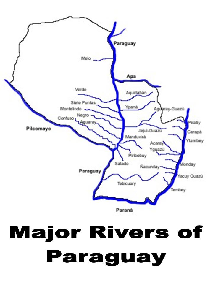
Paraguay is broadly separable into two distinct climatic and vegetative regions - the Chaco and the Orient - the border between the two being the watery expanse of the Río Paraguay. The Chaco consists of three political departments, the Orient fourteen.
The Chaco
The Chaco constitutes 61% of the landmass and is a sparsely-populated, generally dry and arid region, characterised by highly seasonal and unpredictable summer rainfall. The main rivers of the region are the sluggish Río Pilcomayo forming the southern border with Argentina, and the wide Río Paraguay forming the eastern border with Brazil and the Orient. Rainfall is lowest along the Bolivian border (350mm annually) in the north and north-west of the region, and highest in the east of the region along the Río Paraguay (1400mm annually) - the western Chaco, particularly, experiences long and extreme periods of drought which may last for up to nine months. Annual temperatures are amongst the highest in the whole of South America, averaging >25ºC in the west and >23ºC in the east, and regularly above 40ºC in summer. Winter temperatures may dip below freezing for short periods when cold fronts blow in from the southern cone. The Chaco is fairly flat, though there is a west to east gradient in altitude, from a maximum of 400m above sea level in the Bolivian border regions down to less than 100m at the Río Paraguay. The major population centre of the Chaco is the Mennonite settlement of Filadelfia, (pop. 7,062) located on the Ruta Trans-Chaco, the only major, paved road in the region.
The Orient
The Orient, 39% of Paraguay´s territory, is lusher, greener and wetter than the Chaco, with a more complex topographical and vegetational make-up. The region is almost completely bounded by rivers, the Río Paraguay in the west, the Río Apa to the north and the fast-flowing Paraná to the east and south. The areas along the Ríos Paraguay and Paraná are the lowest-lying, less than 100m above sea-level, while the highest elevations in the entire country - up to 760m - are located in the north-eastern and central departments. Similarly high temperatures to the Chaco are experienced in summer, generally with increased humidity, though the overall mean temperatures are lower - from >23ºC in the north-west to >21ºC in the east close to the Brazilian border. Rainfall is more evenly distributed throughout the year, though occasional flash storms in summer make it the wettest season. Rainfall varies from 1200mm annually in the west, to over 1700mm in the east. The vast majority of the population are resident here with the major population centres - greater Asunción (pop.1,620,483) in the west, Ciudad del Este (pop. 333,535) in the east, Encarnación (pop. 69,769) in the south, Pedro Juan Caballero (pop. 64,163) in the north-east and Concepción (pop. 45,068) in the north - all linked by a comprehensive network of paved roads.
Topography of Paraguay
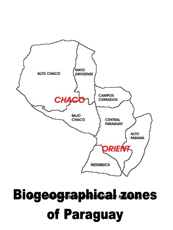
Biogeographical Zones
The following section describes the country on the basis of the predominant habitat, vegetation and topographical types - biogeographical zones. The divisions are purely artifical, especially as the intergradation between the habitats is ecotonal (gradual), but it is useful as a simplified descriptive tool. There are seven biogeographical zones - three in the Chaco and four in the Orient. This division follows Hayes (1995) and Clay and Del Castillo (2004). The following sections give a basic overview of the regional change in habitat types across the country. Specific habitat-types are given in italics in parentheses and described in more detail on the habitat page.
Alto Chaco
(Deptos. western Alto Paraguay, Boquerón and western Presidente Hayes).
A huge region occupying more than 60% of the Chaco and dominated by dense, dry, semi-arid, xerophytic thorn forest (Chaco forest) with a thick undergrowth of bromeliads and cacti. Forests range between 5-10m in height, tallest in the east and south of the region and shortest in the west where cacti predominate. Thorn scub savanna (Matorral) occurs near to the Bolivian border, while man-made, artificial grasslands (Pasture) and wetlands occur along the Ruta Trans-Chaco and in the vicinity of Mennonite colonies. Most rivers (Freshwater bodies), with the exception of the Río Pilcomayo, are narrow and seasonal, being dry for most of the year. The Río Pilcomayo (Freshwater bodies) forms swamps (Freshwater Wetland) at Laguna Escalante and Estero Patiño in western Depto. Presidente Hayes. Shallow saline lakes (Saltwater lagoons) may form temporarily after heavy rains. The subhumid forest (Subhumid Forest) occurring around Cerro León, the region´s highest peak, is taller than in the rest of the Alto Chaco.
Matogrosense
(Deptos. Eastern Alto Paraguay and northern Presidente Hayes).
In the north-eastern Alto Chaco the thorn forest changes abruptly into taller subhumid forest (Subhumid Forest), marking the beginning of the Matogrosense region. Closer to the Río Paraguay (Freshwater bodies) the forest floods (Gallery forest) regularly and wetlands habitats form. Many characteristics of this region are shared with the Brazilian Pantanal, and it is considerably more humid than other Chaco regions. Where the Río Paraguay is narrowest, marshes (Freshwater Wetland) form, and sluggish, temporary streams flow eastwards into the region. Taller forest forms around areas of raised ground, though there is no great altitudinal range. To the south the forest begins to break up as the transistion to the palm savanna (Palm savanna) of the Bajo Chaco becomes evident.
Bajo Chaco
(Depto. Eastern and southern Presidente Hayes).
Dominated by extensive, seasonally-flooded Copernicia palm savanna (Palm savanna), with drier, xerophytic (Chaco forest) forests (8-15m high) forming on higher ground. Several small rivers wind east to the Río Paraguay (Freshwater bodies), bordered in many areas by medium-height (10-20m) subhumid, riparian forest (Gallery forest) and in other areas by marsh. Huge marshes (Freshwater Wetland) form on the northern banks of the Río Pilcomayo in the west of the region, before the transition to thorn forest begins. For the most part the Río Pilcomayo is choked with vegetation and unavigable.
Campos Cerrados
(Deptos. Concepción and northern Amambay).
Covered for the most part by a scrub forest/grassland habitat unique to this part of the world and known as campos cerrados or simply cerrado. These are characterised by a mixture of open, xerophytic, savanna woodland (Cerrado savanna) and more closed, semi-deciduous (Cerrado woodland) woodland (8-20m high), interspersed with bromeliads, shrubs, grassland and savanna. Taller, more humid forest (20-50m high) is found in the Amambay highlands, while the west is almost Chaco-like with palm savanna (Palm savanna) and dry forest (Chaco forest) predominating. Rivers border the region on three sides, the Apa to the north, Paraguay to the west and Ypané to the south, while the Aquidabán approximately bisects the region east to west. River areas are bordered by marsh (Freshwater Wetland) or riparian woodland (Gallery forest) in some areas, and sandy beaches in others. Small streams meandering from these rivers permeate the region, with marsh frequently forming along their course. Altitude increases east towards the Brazilian border, with precipitous cliffs and hillsides typical of the Cordillera de Amambay.
Central Paraguay
(Deptos. San Pedro, Cordillera, Central, southern Amambay, western Canindeyú, western Guairá, Caazapá, central Itapúa).
The most variable of the seven regions, the Río Paraguay area characterised by flat marsh (Freshwater Wetland), palm savanna (Palm savanna) and low humid forest (Atlantic forest and Secondary humid forest). The Bahía de Asunción, the river´s largest bay is located just to the north of the capital city, Asunción. One of the country´s largest lakes (Freshwater bodies), Yparacarai, is located in this region, draining into marsh at its northern edge. To the east the country is hillier and taller, with humid forest taking over - perhaps the traditional vegetation type of this zone before human modification altered the environment. The forest cover is more fragmented than previously, being replaced by agricultural land (Pasture) and secondary growth forest scrub (Capuera). North towards the Río Ypané there is a gradual change towards campos cerrados (Cerrado savanna and Cerrado woodland) vegetation. In the south-west deciduous forest is gradually replaced by the flat grasslands (Natural grassland) of Ñeembucú. In the east a series of Cordilleras, some volcanic in origin, form the border area with Brazil. Lowland marsh (Freshwater Wetland) forms along the Río Manduvirá.
Ñeembucú
(Deptos. Ñeembucú, Misiones, extreme southern Central, western Paraguarí, western Itapúa)
A low-lying, flat region of grassland (Natural grassland and Pasture) and seasonal wetland (Freshwater Wetland), with palm savanna (Palm Savanna) in some areas and low, subhumid (Subhumid Forest), chaco-like forest on higher ground. This region is reminiscent of the Chaco in many respects and may best be included within it. River boundaries (Freshwater bodies) form the western (Río Paraguay) and southern (Río Paraná) limits, while the Río Tebicuary flows east to west through the region. When it is not in flood, broad sandy beaches form along its length in some areas. The Río Paraná is at its widest in this region, thanks in part to the Yacyretá dam project, and islands have formed, some with extensive sand dune systems. Plentiful streams feed considerable marshland areas and lakes are widely distributed, the largest being Ypoá and Verá in the north.
Alto Paraná
(Deptos. Alto Paraná, eastern Canindeyú, eastern Caaguazú, eastern Caazapá, eastern Itapúa).
A hilly region of fast-flowing rivers, dominated by tall, humid forest (Atlantic forest and Secondary humid forest), 20- >25m high, though most have now been cleared or flooded by damming projects along the Río Paraná (Freshwater bodies). In some areas where the forest has been cleared forest scrubland (Capuera) occurs, representing the first stage of regeneration. Hilly ranges form the boundaries of the region, Cordillera Mbaracayú on the Brazilian border to the north, and a series of ranges to the west and east. Paraguay´s only naturally occurring southern temperate forest (Araucaria forest) is found in this region. The major rivers of the region all flow east or south-east into the Río Paraná, forming rapids and waterfalls in many areas. Though isolated, small marshes (Freshwater wetland) are dotted throughout the region, the only extensive area of marshland being in the area around the Upper Río Monday.